
EMF started yesterday, and last week I wanted to do something nerdy to justify my attendance.
To quote the website:
Electromagnetic Field is a non-profit camping festival for those with an inquisitive mind or an interest in making things: hackers, artists, geeks, crafters, scientists, and engineers
So, as conversation of attendance, and the site began to be set up, the nerdy bug caught me and I decided to build a thing.
Last time I went to EMF, I found that I kept losing people on site (because it’s quite large). So maybe I could build something to help people returning to my tent to find out where I was.
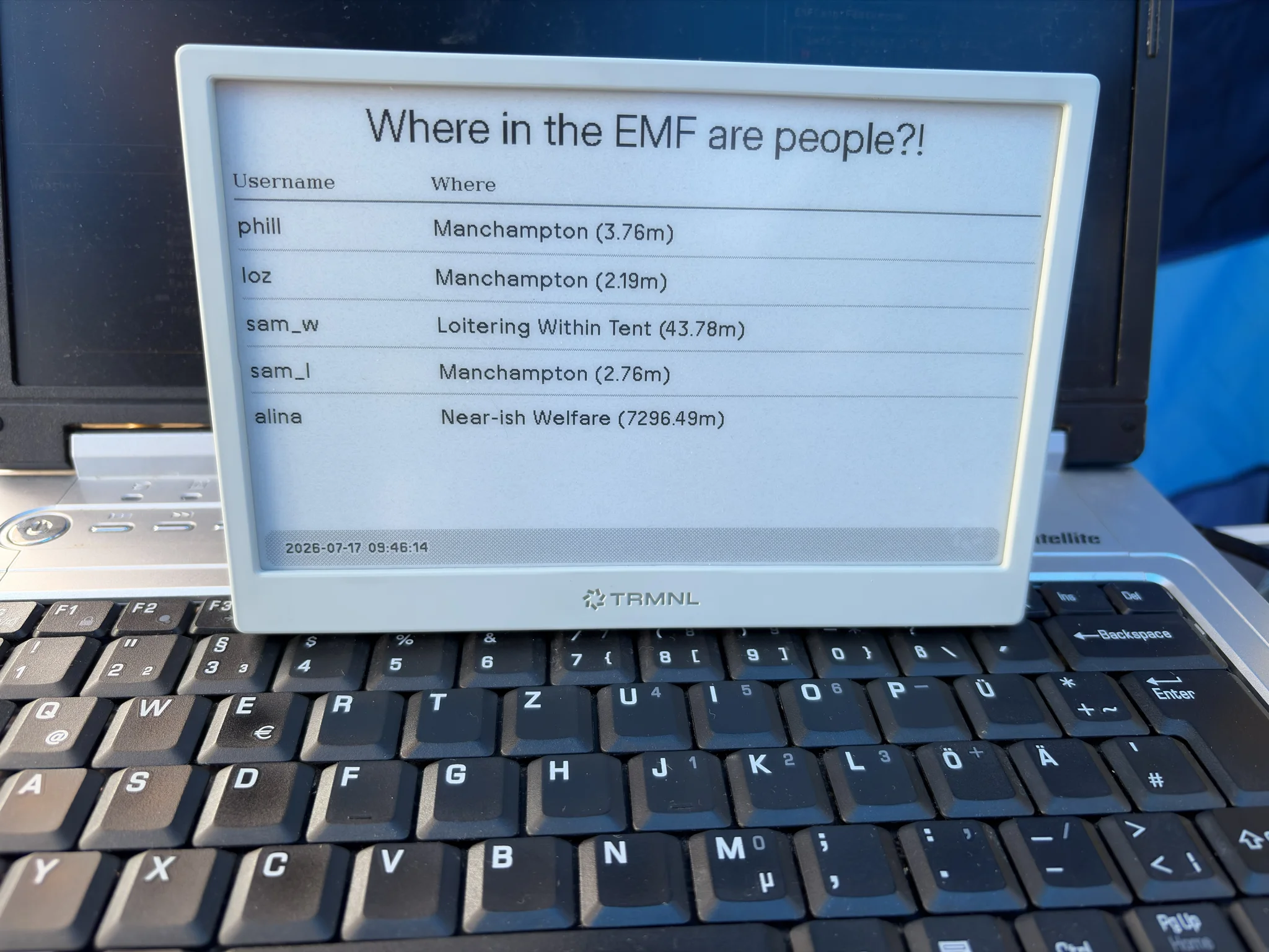
Cue the ‘Where in the EMF are people?!’ dashboard.
A completely overengineered alternative to texting me.
Architecture
I bought a TRMNL ePaper display late last year, and I decided it would be a quick way to display data about where I am. The device dials out to the trmnl cloud and loads a pre-rendered image. It’s a tiny device that literally only does that; pretty cool.
On the other end of the problem space, I wanted a tracker to periodically announce my location. I also wanted to not forget do announce my location, so I needed something automated.
My iPhone seemed like it should reasonably be able to do that, so that was my end to end; somehow I was to get my iPhone to report my location on a schedule, and have my ePaper display the location.
To make it a bit more complicated, I wanted to show which on-site location I was closest to. Latitude and Longitude are a bit tough to work with, so ‘I’m in the pub’ seemed more user friendly.
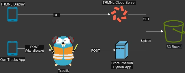
I started with a fully AWS system, but it became clear it was easier to just have a Tailscale network which allowed private access from anywhere. I used a tailscale sidekick container to allow private routing.
So there are three main flows.
Position Reporting
- The phone uses the OwnTracks app to send an HTTPS POST request to the API Gateway
- The request is routed over tailscale, to the Traefik container
- Traefik authorizes and routes to the Python application
- The Python extracts the OwnTracks payload, and stores it in a local SQLLite database
- A 200 OK response is returned to the OwnTracks application with all known locations (which shows them in the app)
- The list of users, their GPS location, their closest EMF location, and their distance from it, are all gathered
- The closest location for each user is taken and if closer than 30 meters to the user, is selected as their current location
- A
dashboard.json,dashboard.html, anddashboard.pngare written to S3 containing the information
Image Rendering
- A Private Plugin on the TRMNL cloud makes a GET request for the
dashboard.jsonon S3 - Custom Markup converts the JSON into HTML, which is captured and cached as an image
Image Display
- The TRMNL device queries the TRMNL server to get the pre-rendered image from the Private Plugin
- Profit.
Onboarding Users
Now, because this is a pet project (and there isn’t a security department shouting at me), there are a couple of steps to onboard a user.
- Add a hard coded username/password pair to the Traefik configuration
- Invite the user to my tailscale
When those two bits of information are updated, a URL with the username and password can be put into the OwnTracks application, and it can start reporting positions.
Future Improvements
- Some proper authentication
- Probably MQTT to support things other than the OwnTracks application
Maybe I will get to these (but we know I won’t).
The source code can be found on my GitHub.